Tabla de contenido
Publicidad
Idiomas disponibles
Idiomas disponibles
Enlaces rápidos
FAQs
Q: What is the normal time that GPS needed to receive the satellite
signal?
A: The normal time is approximately 1 minute in places
Clear and away from buildings. The antenna would be better if it is not
moving.
Q: When should I restart my GPS?
A: When the satellite signal is not received after a certain period of
time (more than 5 minutes). When you have traveled more than 500Km
without using the device.
Q: What is the capacity of the battery?
A: Approximately lasts 4 hours depending on the configuration and
application set. Remember that the initial load is 12 hours.
Battery operated at its full capacity after 4 or 5 cycles of loading.
ENGLISH-02
IMPORTANT CONSIDERATIONS
In the "City", enter the name of your city.
Once you have selected your city, in the "Street" may start search of the
main avenues and streets of this city.
If you can not find the desired street, it is because it is not listed as a
main street or avenue, so you must perform a more specific search.
To this should look into the fields:
"City":
By colony Delegation / Municipality
"Zip":
By Postal Code.
Whether that makes the search for Cologne delegation / or Municipality
Postcode suffice to enter some data close to the street you are looking
for, it is not necessary that the data is accurate, only a further data to
support the GPS to find the address you are looking for.
IMPORTANT
ENGLISH-03
Publicidad
Tabla de contenido

Manuales relacionados para Steren GPS-400

Resumen de contenidos para Steren GPS-400
- Página 1 IMPORTANT CONSIDERATIONS FAQs In the “City”, enter the name of your city. Q: What is the normal time that GPS needed to receive the satellite signal? Once you have selected your city, in the “Street” may start search of the main avenues and streets of this city.
- Página 2 Before using your new GPS Navigation System, read this • Do not place the device on blankets, carpet, or any other thick • Do not leave this unit under the front windshield after you leave the instruction manual to avoid any malfunctions. fabric as this could cause the device to overheat and be damaged.
-
Página 3: What Is Gps
WHAT IS GPS? WHAT CAN BE DONE WITH A GPS? FEATURES The Global Positioning System (GPS) is a Global Navigational Considering that a GPS device can give us our exact location and • High sensitivity internal receiving antenna Satellite System (GNSS) which allows for the determination of an altitude with great precision, some of the activities than can be used are: •... - Página 4 ACCESSORIES ENERGY SOURCE Using Home / Travel adapter: 1.- Insert the connector into the unit. The GPS device can be used with a battery (rechargeable) or with the 2.- Plug the adapter into a power outlet. home or vehicle power adaptor. We recommend a full charge of the battery before to use the GPS by first time.
- Página 5 Front View bracket. 2.- Insert the other end into the cigarette lighter. If the battery suffers a malfunction, please contact to your nearest STEREN distributor. 1.- Charging indicator This LED will light in red when the battery is charging 1.- Stylus At the end of the charge, the LED will be green.
- Página 6 Left Side Up side PLACING THE EQUIPMENT 1.- SD card slot. 1.- Menu. Your new GPS device comes with all the equipment necessary to place Use to enter main menu it in your car without the need of any perforations or structural changes 2.- Earphone port.
- Página 7 2.- Turn the knob to the right until it is firmly pressed both pieces. 4.- Based place on the windshield, then lower the insurance support to The recommended installation location is illustrated below. fix the rubber clamp to the windshield. Do not block visibility Do not place in front of...
-
Página 8: Getting Started
GETTING STARTED The included memory card contains the digital map files that are USING THE STYLUS required for the GPS navigational data. Please do not delete. If you are a first-time system user, the following explanations will help When removing the memory card, please make sure the card is not you to quickly understand the system operations, and experience the This unit can be controlled easily though the touch screen. -
Página 9: Operating Methods
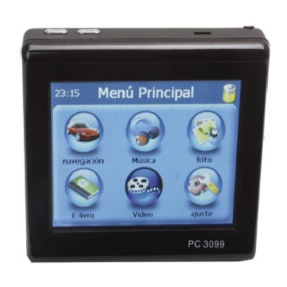
OPERATING METHODS MAIN MENU Through this menu you will be able to access 6 different sub-menus where you will be able to set the following options: Startup Press the power button for 3 seconds in order to power the GPS device 1.- For first time use, please turn the system power switch at the rear on. - Página 10 ICONS NAVIGATION On the left hand panel, there are four large buttons: The following icons are used throughout the application: This section will show you how to use the personal navigation system quickly and easily. You will learn how to use all of the available options Icon Name Function...
- Página 11 • Use Settings to configure your personal navigation system to suit 1.- Time your needs. Define general settings (e.g. time, language, system 2.- Elevation above mean sea level The map is the core component of your personal navigation system. of measurement, see page 56), configure your map (e.g. 2D or 3.- Geographic coordinates It is centred on your current location by default, provided you have a 3D mode, day or night mode, map complexity) or load a map of a...
-
Página 12: Navigation Screen
• Use the stylus to browse the map. The selected position will be NAVIGATION SCREEN The navigation screen displays your route (in blue) and your identified by a cursor. surroundings. The GPS position symbol identifies your current position. The red arrow indicates the direction of your next turn. The upcoming Clicking on an icon on the map will open an overlay window with manoeuvre is always displayed in the upper left corner –... - Página 13 CHOOSING AND FINDING LOCATIONS How to search Set the country Your Personal Navigation system offers a convenient interactive • To select your country, press Country This section describes the different ways of finding and choosing look-ahead search function to prevent misspelling. Only keys that lead •...
- Página 14 Search for the street NAVIGATE TO THE ADDRESS FOUND SEARCHING FOR AND CHOOSING POIs • To select a street, press Street. Once you have narrowed down your search to a unique address, you The POI finder allows you to quickly find points of interest like petrol •...
- Página 15 A menu with subcategories will be shown. • To navigate to the location, press Navigate (see page 29). Choosing a location on the map • Select a subcategory (if applicable). • To use the location for planning a route, press Via (see page 53). An easy way to choose a location is selecting it on the map.
- Página 16 FAVOURITES • Press Bookmarks. • To show the location on the map, press On Map. • To edit the location, press Rename. Use your frequently used or favourite destinations for guidance. You can The bookmark list will show on the screen: •...
-
Página 17: Menu Options
Trips NAVIGATING MENU OPTIONS • To access to your previously saved trips, i.e. routes, press pressing The powerful navigation capabilities of your Personal Navigation • To open a set of navigation options during navigation, press the Trips. System guide you along the shortest or quickest route from A to B – with menu icon: voice commands and in 3D. - Página 18 Way list PLANNING A ROUTE The location will be added to the Destination List. Opens a list of the waypoints (manoeuvres) along your route. • To add another stopover, press the + icon. This feature allows you to plan your route in advance, choosing multiple stopovers along your journey.
- Página 19 Once you have chosen your route, you have several options. You reach SETTINGS General settings those options by pressing the menu icon (bottom right-hand corner of • Choose General to change the general settings. the screen). You can configure your Personal Navigation System to suit your needs. The window with the general settings will be shown: When it comes to navigating, you can, for example, choose to avoid or allow toll roads or ferries or select your mode of transportation, like...
- Página 20 Map settings • To toggle between 2D and 3D modes, press the corresponding Route options • Choose Map Options to change the map settings. icon. • Select Settings • To optimize the map orientation during navigation, press Track Up. • Choose Route Settings to change the route options.
- Página 21 Once you have chosen your settings, press the confirmation icon to MUSIC PLAYBACK FUNCTION STARTING MUSIC PLAYBACK return to the main menu. This unit is capable of playing back MP3, WAV files stored on SD 1.- Insert the SD memory card with stored MP3 files into the SD memory Mode of transportation - Overview memory cards.
- Página 22 DESCRIPTION OF THE MUSIC MENU IMAGE BROWSING FUNCTION DESCRIPTION OF THE PHOTO MENU 1.- The system has an Image Browsing function that is capable of displaying images/photographs stored on SD memory cards. All the files needs to be JPG, GIF, BMP or PNG. 2.- Insert the SD memory card with stored image files into the SD memory card slot on the unit.
-
Página 23: Menu Video
SYSTEM MENU VIDEO To view the image in full screen, press the Full Screen icon. To The other function gives you the ability to adjust the basic system return to the previous state press twice on the screen. options, including date/time settings, volume control, sytem info, power, Video can read the film with the following data format: .wmv, .avi, .mpeg backlight, lenguage. - Página 24 DESCRIPTION OF THE VIDEO MENU MENU E-BOOK DESCRIPTION OF THE eBOOK MENU eBook function can only read files in txt format, please save them onto the SD memory card in a folder named “ebook”. 1.- Insert the SD memory card with eBook files into the SD memory card slot on the unit.
- Página 25 SETTING 4.- Select Hour ; first option is the hour, and second option are the minu- VOLUME tes. Choose > to increase the digit or < to decrease the digit. Press X Raise the volume lavel with + or - to reduce the level. to exit.
-
Página 26: Factory Reset
POWER LANGUAGE SYTEM INFO 1. Select system, press power. this option will show the level of energy 1.- Select System and press Sys Info available. 1.- Select system, press lenguage. 2.- The screen displays the system infomation. 2.- Press > or < to change lunguage 3.- If you want to change the color of the screen press >... - Página 27 RESET GPS TROUBLESHOOTING SPECIFICATIONS Problem Solution Under this option resets the GPS satellite receiver Screen: TFT 3,5” 320 x 240 pixels. The SD/MMC card cannot be The card is probably positioned 1.- Select System and press Sys Info, select reset GPS. placed in the slot incorrectly.
- Página 28 Name of the retailer Input: 1,5A WARRANTY Address This Steren product is warranted under normal usage against defects in workmanship and AC adaptor materials to the original purchaser for one year from the date of purchase. Product Input: 100-240 V~ 50-60 Hz 0,5 A...
-
Página 29: Preguntas Frecuentes
PREGUNTAS FRECUENTES CONSIDERACIONES IMPORTANTES P: ¿Cúal es el tiempo normal que el GPS necesita para recibir la señal En el campo “Ciudad”, introduzca el nombre de su Ciudad o colonia. del satélite? Una vez que haya seleccionado su Ciudad, en el campo “Calle” podrá R: El tiempo normal es de aproximadamente 1 minuto en lugares iniciar la búsqueda de las principales calles y avenidas de dicha ciudad. - Página 30 Antes de utilizar su nuevo Sistema de ubicación satelital GPS lea • Coloque el equipo en una superficie plana. • Cualquier producto de comunicación inalámbrica (teléfono móvil, este instructivo para evitar cualquier mal funcionamiento. • No coloque el dispositivo sobre la alfombra, almohadas o radio, unidad de detección de velocidad, etc.) podría afectar a la Guárdelo para futuras referencias.
-
Página 31: Características
¿QUÉ ES EL GPS? ¿QUE PUEDE HACER CON UN GPS? CARACTERÍSTICAS El sistema GPS (Global Positioning System) o Sistema de Considerando que un equipo GPS puede darle su ubicación exacta, • Antena interna de recepción de alta sensibilidad. Posicionamiento Global es un sistema compuesto por una red de 24 algunas de las actividades en las que se puede utilizar son: •... -
Página 32: Fuente De Energía
ACCESORIOS FUENTE DE ENERGÍA Utilizando el cargador casero / de viaje: 1.- Inserte el conector del adaptador de corriente en la unidad. El dispositivo GPS puede utilizarse mediante un eliminador –de auto 2.- Inserte el adaptador de corriente a un contacto eléctrico. o casero-. - Página 33 1.- Inserte el conector del adaptador en el equipo. 2.- Conecte el adaptador de corriente en el encendedor para cigarrillos. En caso de que la batería sufra alguna falla, acuda con el distribuidor autorizado Steren más cercano. 1.- LED indicador de carga 1.- Estilógrafo El LED se encenderá...
-
Página 34: Colocando El Equipo
Lateral Izquierdo COLOCANDO EL EQUIPO Vista superior 1.- Ranura para tarjetas SD. 1.- Menú. Su equipo cuenta con los aditamentos necesarios para su colocación Permite regresar al menú principal. en el automóvil sin necesidad de realizar ninguna perforación o cambio 2.- Salida para audífonos. - Página 35 4.- Coloque la base en el parabrisas, baje el seguro a fin de fijar la A continuación se ilustra la ubicación de instalación recomendada. 2.- Gire la perilla hacia la derecha hasta que queden firmemente sujetas goma de sujeción al parabrisas. ambas piezas.
-
Página 36: Procedimientos Iniciales
La tarjeta de memoria incluida contiene archivos de mapas PROCEDIMIENTOS INICIALES ESTILÓGRAFO digitales que son necesarios para los datos de navegación por Si es la primera vez que utiliza el sistema, las siguientes explicaciones GPS. No los elimine. le ayudarán a comprender rápidamente el funcionamiento del mismo y Esta unidad se puede controlar fácilmente a través de la pantalla táctil. - Página 37 A través de este menú podrá acceder a 6 diferentes sub-menús, en donde podrá configurar las siguientes opciones: MÉTODOS DE FUNCIONAMIENTO MENU PRINCIPAL Encender el dispositivo Presione el botón de Encendido por tres segundos para encender el 1.- Cuando utilice el dispositivo por primera vez, coloque el conmutador equipo, posteriormente entrará...
- Página 38 NAVEGACIÓN En el panel de la izquierda, existen 4 opciones: AJUSTE Esta sección le mostrará como utilizar el Sistema de Navegación Accede a las funciones donde podrá cambiar los parámetros de Personal de una forma fácil y sencilla. Podrá conocer todas las volumen, luz de fondo, energía, fecha/hora, idioma e información del opciones disponibles y la mejor forma de llegar de un punto a otro.
-
Página 39: Modo De Seguimiento Y Modo De Exploración
• Mediante Ajustes puede configurar su dispositivo de navegación MAPA 1.- Hora personal para que se adapte a sus necesidades. Defina los ajustes 2.- Altitud El mapa es el componente principal del dispositivo de navegación generales (como hora, idioma, sistema de medida, consulte la 3.- Coordenadas personal. -
Página 40: Pantalla De Navegación
• Examine el mapa con el stylus. La posición seleccionada se PANTALLA DE NAVEGACIÓN La pantalla de navegación muestra su ruta (en azul) y sus alrededores. identifica mediante un cursor. Los cursores indican su posición actual. La flecha roja indica la dirección de su próximo giro. -
Página 41: Elección Y Búsqueda De Ubicaciones
Introduzca los datos necesarios para encontrar su dirección. Para alternar entre el modo numérico y el alfabético, pulse 123 o ELECCIÓN Y BÚSQUEDA DE UBICACIONES ABC. Esta sección describe las diferentes formas de buscar y seleccionar Procedimiento de búsqueda Si en cualquier punto necesita retroceder y borrar caracteres, ubicaciones. -
Página 42: Navegación Hasta La Dirección Encontrada
Búsqueda de la ciudad (Colonia) BÚSQUEDA Y SELECCIÓN DE PUNTOS DE INTERÉS NAVEGACIÓN HASTA LA DIRECCIÓN ENCONTRADA Para seleccionar una Colonia, pulse Ciudad. El buscador de Puntos De Interés permite localizar rápidamente sitios Una vez realizada la búsqueda a una dirección, puede empezar a •... - Página 43 Aparecerá un menú con subcategorías. • Para navegar hacia el lugar, pulse Navegar (consulte la página 29). • Para mostrar el lugar en el mapa, pulse En el mapa. • Si desea utilizar el lugar para planificar una ruta, pulse Vía •...
- Página 44 La lista de favoritos aparecerá en pantalla: Toda la información del usuario, como los ajustes, los favoritos y PERSONAL los lugares visitados recientemente, se almacenará en la tarjeta de Utilice sus destinos personales o frecuentes como guía. Puede memoria y no en el dispositivo. seleccionar alguno de sus favoritos, lugares visitados recientemente, viajes guardados anteriormente y los preestablecidos (como su casa o Últimos...
-
Página 45: Opciones De Navegación
Viajes OPCIONES DE NAVEGACIÓN OPCIONES DE MENÚ • Para tener acceso a los viajes guardados anteriormente, pulse Las enormes capacidades de navegación de su dispositivo de • Para abrir un conjunto de opciones de navegación durante la Viajes. navegación personal le guían por el camino más corto o más rápido de navegación, pulse el icono de menú: A a B, mediante comandos de voz y en tres dimensiones. -
Página 46: Planificación De Rutas
Guardar PLANIFICACIÓN DE RUTAS La ubicación se añadirá a Lista de Destinos. Guarda su posición actual como un favorito. • Para añadir otro punto de trayecto, pulse el icono +. Esta función le permite planificar su ruta por adelantado, seleccionando múltiples puntos de trayecto durante su viaje. - Página 47 Una vez que ha elegido su ruta, tiene varias opciones. Para verlas, AJUSTES Aparecerá la siguiente ventana: pulse el icono del menú (en la esquina inferior derecha de la pantalla). Puede configurar su dispositivo de navegación personal para adaptarlo a sus necesidades. Por ejemplo, al navegar, puede elegir evitar o permitir los peajes o ferries o bien seleccionar su modo de transporte, como un automóvil lento o rápido, un scooter o incluso a pie.
- Página 48 Aparecerá la ventana con los ajustes de mapa: • Para seleccionar los elementos que se van a mostrar en el mapa, Opciones de ruta pulse Info mapa: • Seleccione Ajustes. • Seleccione Opciones de ruta para cambiar las opciones de ruta. Aparecerá...
-
Página 49: Reproducción De Música
Modo de transporte: visión general REPRODUCCIÓN DE MÚSICA INICIAR LA REPRODUCCIÓN DE MÚSICA Esta unidad es capaz de reproducir archivos MP3, WAV almacenados Rápido: presupone la conducción rápida en autopistas. Al elegir esta en tarjetas de memoria SD. 1. Inserte la tarjeta de memoria SD que contenga los archivos MP3 en opción, se dará... -
Página 50: Descripción De La Pantalla De Música
DESCRIPCIÓN DE LA PANTALLA DE MÚSICA EXPLORACIÓN DE IMÁGENES DESCRIPCIÓN DE LA PANTALLA DE FOTOGRAFÍAS 1.- El sistema tiene una función de exploración de imágenes capaz de mostrar imágenes y fotografías almacenadas en tarjetas de memoria Es necesario almacenar todos los archivos con el formato de archivo JPG, GIF, BMP O PNG. -
Página 51: Menu De Ajuste
MENU DE AJUSTE MENU DE VIDEO Si desea ver la imagen en pantalla completa, presione el icono La función Ajuste le proporciona la posibilidad de ajustar las opciones Pantalla completa. se activará la secuencia de fotos almacenadas básicas del sistema, como por ejemplo la fecha/ hora, el control de La función de vídeo puede leer películas con los siguiente formatos de en la memoria SD. -
Página 52: Descripción De La Pantalla De Video
DESCRIPCIÓN DE LA PANTALLA DE VIDEO MENU LIBROS DESCRIPCIÓN DE LA PANTALLA DEL LIBRO ELECTRONICO La función Libros permite leer archivos con la extensión txt. Guárdelos en la tarjeta de memoria. 1.- Inserte la tarjeta de memoria SD que contenga los archivos de eBook en la ranura para tarjetas de memoria SD de la unidad. -
Página 53: Configuración
4.- Seleccione HORA; la primera opción corresponde a la Hora y la CONFIGURACIÓN VOLUMEN segunda opción a los Minutos. Presione > para aumentar el digito o < para disminuir el digito. Presione X para salir. 1. Seleccione Sistema del menú principal, posteriormente presione FECHA/HORA Volumen. -
Página 54: Iluminacion
ENERGIA VERSIÓN IDIOMA 1.- En Sistema seleccione Energía, en esta opción se mostrara el nivel 1. Seleccione Ajuste, posteriormente info. sist. de energía disponible en el equipo. 2. La pantalla mostrará la información de la versión. 1.- Seleccione el icono ajustes, posteriormente presione Idioma. 2.- >... -
Página 55: Ajuste Del Estilógrafo
RESET GPS PROBLEMAS Y SOLUCIONES ESPECIFICACIONES En esta opción resetea el receptor satélite del GPS Problema Solución 1.- Seleccione Ajuste, presione info. sist. y reset GPS. Pantalla: TFT 3,5” 320 x 240 pixeles La tarjeta se está insertando de 2.- La pantalla le mostrará lo siguiente: ¿Quiere resetear el receptor La tarjeta SD//MMC no se puede forma incorrecta, cambie la satélite del GPS? con la opción si o no. -
Página 56: Póliza De Garantía
Electrónica Steren S.A. de C.V. Centro de Atención a Clientes Adaptador Automotriz 2.- Electrónica Steren S.A de C.V. se compromete a reparar el producto en caso de estar 01 800 500 9000 Número de serie defectuoso sin ningún cargo al consumidor. Los gastos de transportación serán cubiertos...